|
Digital Elevation Model (DEM) landscapes
are just a collection of heights or elevations that represent
a rectangular area of the real world or an imaginary
world.
Elevations are sampled at regular intervals in the
North-South and East-West directions. Typical
sample intervals or X and Y spacings are 10, 30, 90
and 1,000 meters.
AccuTrans 3D reads landscapes from several different
file types. Many file types use the DEM file
extension but the file format is different.
- ASCII height files.
- Binary height files.
- CDED DEM files.
- Contour line files.
- Contour map files as 256 color BMP
and 32 color IFF.
- MicroDEM DM files.
- Scenery Animator (Amiga) files.
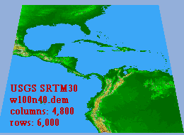
- USGS 1-degree DEM files.
- USGS GTOPO30 files.
- USGS SRTM-1 files.
- USGS SRTM-3 files.
- USGS SRTM30 files.
- USGS STDS files.
- VistaPro files.
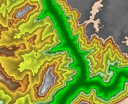
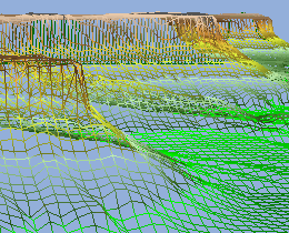
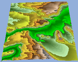
AccuTrans 3D displays the landscape as a 3D wireframe
mesh or a 3D solid rendered surface or as a 2D contour
map.
The 2D contour map uses 4 colors for elevations
below sea level, one color for sea level and 239 colors
for elevations above sea level.
The colors used in the 2D contour map are displayed
on the 3D landscape.
Editing tools are available for painting or cutting
and pasting brushes on the 2D contour map so that the
elevations of the landscape can be altered. For
greater flexibility save the contour map to a 256 color
BMP file and alter the map in your favorite paint program.
Create a new contour map of any size in your paint
program, save it as a 256 color BMP file and then have
AccuTrans 3D convert the BMP file to a 3D landscape.
Save as a 3D mesh to any supported 3D file format.
Save as heights only to an ASCII or Binary file.
Save as a contour map to a 256 color BMP file.
Save as longitude and latitude profiles to a DXF
file.
Save as either an ASCII or Binary XYZ file.
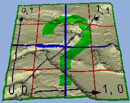
Texture maps can be displayed on any landscape.
Just specify the texture file name and AccuTrans 3D
automatically calculates the UV coordinates and displays
the texture map on the 3D landscape. The lower
left corner of the bitmap is placed at the SW corner
of the landscape. Once the texture map is displayed
the 3D landscape including UV coordinates can be saved
to any 3D file format that supports UV texture coordinates.
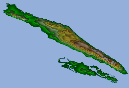
Without writing to a file, the landscape can be
converted to a 3D object including UV coordinates and
with the lowest elevations of the landscape deleted
from the 3D object. In the example picture,
the 2D contour map was saved to a BMP file. The
landscape was converted to a 3D object and the triangles
at sea level were deleted. The BMP file was
then applied to the 3D islands as a UV texture map.
|